Ozarks Guide
Ozarks Springs Guide: Major Springs, Trails and Public Access
The Ozarks are built around karst — soluble limestone and dolomite that allow water to disappear underground, move through caves and conduits, then return at springs.
This guide focuses on major publicly visitable Ozarks springs in Missouri and Arkansas: how to reach them, what is there, what visitors may actually do, and where to check current conditions or rules.
Missouri & Arkansas Ozarks · Ozarks Guides

Why the Ozarks has so many springs
Why the Ozarks has so many springs
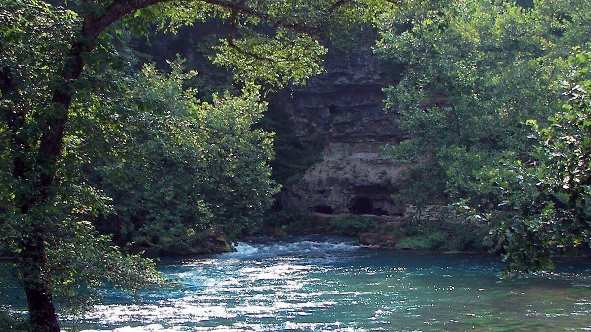
Water moves quickly through fractures, sinkholes and underground passages in Ozarks bedrock. That underground drainage creates springs that feed some of the region's best-known rivers, including the Current, Jacks Fork, Eleven Point and Spring rivers.
Large springs are not simply scenic pools. They are living aquatic systems, river headwaters, trout habitat and evidence of the cave networks beneath the Ozarks.
Clear spring water should not be assumed safe to drink. In Ozark karst, groundwater can move through large underground conduits without the kind of natural filtration people sometimes associate with springs.
Current River and Jacks Fork springs
Current River and Jacks Fork springs
Big Spring — Van Buren, Missouri
Big Spring is Missouri's largest spring and one of the largest freshwater springs in the country.
- Location: about 4 miles south of Van Buren.
- Manager: National Park Service.
- Average flow: roughly 286–289 million gallons per day.
- Access: developed public area with parking and trails.
- Nearby: campground, picnic areas, Current River access and Civilian Conservation Corps historic structures.
- Best for: an easy-to-reach major spring with river and park access.
The spring sends a huge volume of cold groundwater directly toward the nearby Current River.
Alley Spring — near Eminence, Missouri
Alley Spring combines one of the Ozarks' major springs with the historic red Alley Mill.
- Location: about 6 miles west of Eminence on Highway 106.
- Manager: National Park Service.
- Average flow: roughly 89 million gallons per day.
- Access: developed public area with parking.
- Nearby: Alley Mill, campground, Jacks Fork access and trails.
- Best for: spring scenery plus Ozarks cultural history.
The spring branch flows into the Jacks Fork, and spring water historically powered the mill.
Blue Spring — Current River hills, Missouri
Blue Spring is Missouri's deepest known spring and one of the most visually distinctive springs in the Ozarks.
- Manager: Missouri Department of Conservation.
- Depth: about 300 feet.
- Average flow: about 90 million gallons per day.
- Access: about 0.25 mile from the Blue Spring parking area.
- Alternative trail: about 1.5 miles from Powder Mill.
- Best for: a short public hike to a deep blue spring.
- Important: swimming, wading, fishing and boating are prohibited in the spring and spring branch.
A canoe approach from the Current River is also possible, but water entry into the spring itself is prohibited.
Round Spring — north of Eminence, Missouri
Round Spring rises in a nearly circular pool and flows through a natural opening toward the Current River.
- Location: about 13 miles north of Eminence on Highway 19.
- Manager: National Park Service.
- Average flow: roughly 26–30 million gallons per day.
- Access: accessible paved trail from the developed public area.
- Nearby: campground, picnic area, Current River access and ranger station.
- Best for: easy spring viewing combined with river recreation.
- Important: swimming and wading are prohibited in the spring and spring branch.
Welch Spring — near Akers, Missouri
Welch Spring combines a large spring with the ruins of an unusual early-20th-century hospital.
- Manager: National Park Service.
- Trail: about 0.8 mile round trip.
- Access: trailhead off Highway K north of Akers.
- Trail type: easy walk on uneven natural surfaces.
- Nearby: Welch Hospital stone ruins and the Current River.
- Best for: short spring hike plus unusual Ozarks history.
- Accessibility: trail is not wheelchair accessible because of uneven surfaces, inclines and rocks.
Eleven Point and eastern Missouri springs
Eleven Point and eastern Missouri springs
Greer Spring — Oregon County, Missouri
Greer Spring is Missouri's second-largest spring and one of the most important water sources for the Eleven Point River.
- Manager: Mark Twain National Forest.
- Public natural area: recognized by Missouri Department of Conservation.
- Average flow: about 210 million gallons per day.
- Trail: about 1 mile one way from the Highway 19 trailhead.
- Spring branch: just over 1 mile before entering the Eleven Point River.
- Best for: a substantial spring hike and a direct look at how Ozarks springs feed major rivers.
Missouri trout-park and recreation springs
Missouri trout-park and recreation springs
Bennett Spring — near Lebanon, Missouri
Bennett Spring is both a major Ozarks spring and one of Missouri's best-known trout parks.
- Manager: Missouri State Parks.
- Average flow: more than 100 million gallons per day.
- Public use: trout fishing, hiking, camping and picnicking.
- Facilities: nature center, lodging, campground and dining facilities.
- Best for: developed spring access with trout fishing and trails.
Fishing seasons, tags, hours and zone rules change. Check current Missouri State Parks and MDC information before fishing.
Montauk State Park springs — near Salem, Missouri
The springs at Montauk State Park combine with Pigeon Creek to form the headwaters of the Current River.
- Manager: Missouri State Parks.
- Combined spring and creek flow: more than 40 million gallons per day into the Current River.
- Public use: trout fishing, hiking, camping and picnicking.
- Nearby: historic 1896 gristmill.
- Best for: seeing a spring-fed river at its headwaters.
Montauk's headwaters are a spring system rather than one isolated spring pool.
Roaring River Spring — near Cassville, Missouri
Roaring River Spring rises in a steep canyon-like gorge in the southwestern Missouri Ozarks.
- Manager: Missouri State Parks.
- Flow: more than 20 million gallons per day.
- Water temperature: about 57 degrees.
- Public use: trout fishing, hiking, camping and nature-center visits.
- Nearby: Roaring River Hills Wild Area and multiple park trails.
- Best for: southwest Missouri spring scenery combined with developed recreation.
Maramec Spring Park — near St. James, Missouri
Maramec Spring Park is publicly visitable but privately managed by the James Foundation.
- Management: private nonprofit park; trout management is coordinated with Missouri Department of Conservation.
- Public use: trout fishing, walking, historic iron works and park recreation.
- Location: about 6 miles southeast of St. James on Highway 8.
- Important: vehicle entry fees and current park hours may apply.
- Best for: a major spring with trout access and industrial history.
Because it is not public land, check the park's current access rules before visiting.
Lake of the Ozarks karst
Lake of the Ozarks karst
Ha Ha Tonka Spring — Camdenton, Missouri
Ha Ha Tonka Spring sits below a dramatic karst landscape of bluffs, caves, sinkholes and a natural bridge.
- Manager: Missouri State Parks.
- Spring rank: Missouri's 12th-largest spring.
- Flow: more than 48 million gallons per day.
- Access: trails and boardwalks through the karst area.
- Alternate spring access: the Spring Day-Use Area provides a lower-elevation approach.
- Nearby: castle ruins, natural bridge, sinkholes and Lake of the Ozarks.
- Best for: seeing a spring as part of a larger Ozarks karst landscape.
A roughly half-mile paved path from the Lake Picnic Area leads toward the spring overlook; beyond that, stairs and boardwalk terrain may limit some users.
Official natural-history information · Accessibility information
Arkansas Ozarks springs
Arkansas Ozarks springs
Mammoth Spring — Mammoth Spring, Arkansas
Mammoth Spring is one of the largest springs in the region and the source of the Spring River.
- Manager: Arkansas State Parks.
- Designation: National Natural Landmark.
- Flow: roughly 9 million gallons per hour.
- Spring lake: about 10 acres.
- Public use: walking, picnicking and historic interpretation.
- Nearby: depot museum, former hydroelectric plant and Spring River trout water.
- Best for: the clearest Arkansas example of a major spring becoming a major river.
Official state-park information · Spring River fishing context
Blanchard Springs — Stone County, Arkansas
Blanchard Springs emerges from the hillside in the Ozark National Forest near North Sylamore Creek.
- Manager: U.S. Forest Service.
- Access: public recreation area with paved access to the spring.
- Nearby: North Sylamore Creek, hiking, fishing and Blanchard Springs Caverns.
- Best for: an easy public spring visit paired with a larger forest recreation area.
Cavern tours, roads and individual recreation facilities can close independently, so check current Forest Service status before visiting.
Cave Springs Cave Natural Area — Cave Springs, Arkansas
This natural area protects a groundwater-fed cave stream and sensitive Ozark cave habitat.
- Manager: Arkansas Natural Heritage Commission.
- Trail: 1.45 miles round trip.
- Difficulty: easy to moderate.
- Access: lower loop follows Partners Lake and passes Cave Springs Cave; upper loop climbs above the cave.
- Parking: available near the Illinois River Watershed Partnership Sanctuary / local trail approach.
- Ecology: important habitat for Ozark cavefish, gray bats and other sensitive species.
- Best for: northwest Arkansas spring/cave ecology on a public hiking trail.
- Important: this is a protected natural area, not a recreational cave-entry site.
Rock Creek Natural Area / Bubbling Springs — Sharp County, Arkansas
Rock Creek Natural Area combines spring-fed creek habitat with a short public hiking trail.
- Manager: Arkansas Natural Heritage Commission; co-managed with Arkansas Game and Fish Commission.
- Location: within Harold E. Alexander Spring River WMA.
- Trail: about 1.2 miles round trip.
- Difficulty: easy to moderate; not ADA accessible.
- Route: trail parallels Bubbling Springs Hollow.
- Highlight: Bubbling Springs at the end of the trail.
- Best for: a less-developed Arkansas spring hike in protected natural habitat.
The surrounding WMA allows hunting, so check current seasons and take appropriate precautions.
Before you visit an Ozarks spring
Before you visit an Ozarks spring
Do not assume you can enter the water
Within Ozark National Scenic Riverways, swimming, wading and fishing are generally prohibited in springs and spring branches. Other managers have their own rules.
Clear spring water is not automatically safe to drink
Ozarks groundwater can travel quickly through caves and underground conduits. Clear appearance does not guarantee drinking-water safety.
Stay on public land and designated trails
Some springs are surrounded by private property, sensitive habitat or restricted cave systems.
Protect spring vegetation
Spring branches support specialized plants and aquatic animals. Avoid trampling vegetation or disturbing the spring edge.
Check current park information
Before driving, confirm:
- closures;
- road access;
- park hours;
- fishing rules;
- entry or parking fees;
- trail conditions;
- seasonal visitor-center or tour schedules.
Official spring and park pages worth bookmarking
Official spring and park pages worth bookmarking
- Ozark National Scenic Riverways — springs and seeps
- Ozark National Scenic Riverways — places to go
- Missouri Department of Conservation — Blue Spring
- Missouri Department of Conservation — Greer Spring
- Missouri State Parks
- Missouri trout parks
- Arkansas State Parks — Mammoth Spring
- Arkansas Natural Heritage Commission — natural areas
- Ozark-St. Francis National Forests
Ozarks Calendars
Ozarks Calendars
For ranger programs, trout events, interpretive hikes, nature-center programs and other outdoor events, browse Ozarks Calendars.